
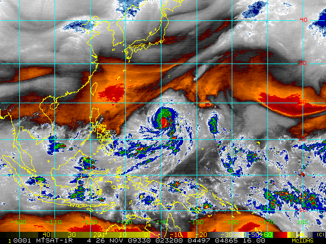

Extremely Catastrophic Super Typhoon NIDA (26W) has reached its peak and is now slowly weakening...still moving northwesterly across the warm seas of the Western Pacific.
*Residents and visitors along the Eastern Coast of the Philippines should closely monitor the progress of NIDA.
*Do not use this for life or death decision. This advisory is intended for additional information purposes only. Kindly refer to your country's official weather agency for local warnings, advisories & bulletins.
Current Storm Information
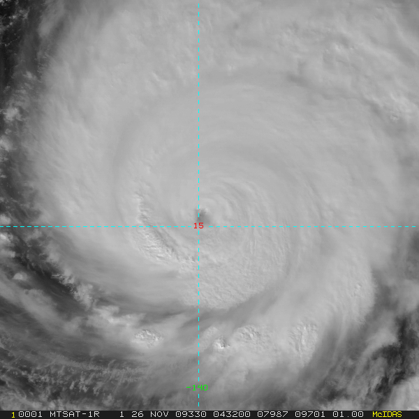
Time/Date: 12:00 PM PST Thu Nov 26 2009
Location of Eye: 15.1º N Lat 140.1º E Lon
Distance 1: 540 km (290 nm) WNW of Guam, CNMI
Distance 2: 545 km (295 nm) East of P.A.R.
Distance 3: 1,700 km (917 nm) ENE of Bicol Region, PH
MaxWinds (1-min avg): 280 kph (150 kts) near the center
Peak Wind Gusts: 335 kph (180 kts)
6-hr Rain Amounts (near the center): 220 mm [Heavy]
Minimum Central Pressure: 911 millibars (hPa)
Saffir-Simpson Typhoon Scale: Category 5
Present Movement: NW @ 20 kph (11 kts)
Towards: Northern Philippine Sea
Size (in Diameter): 665 km (360 nm) / Large
Max Sea Wave Height (near center): 44 ft (13.3 m)
Coastal Storm Surge Height: >18 feet [5.5 m]
Forecast Outlook: NIDA remains a very intense system and is expected to continue losing strength while moving NW to NNW for the next 24 to 48 hours. The 3 to 5-day Long-Range Forecast shows the system slowing down as it weakens to Category 2 and will begin to recurve sharply towards the NE beginning Sunday morning (8AM Nov 29: 19.9N 138.4E)...about 1,710 km East of Batanes Group of Islands. NIDA will continue too accelerate NE-ward on Monday through Tuesday...will be downgraded into a Tropical Storm as increasing upper-level winds (aka. Vertical Wind Shear) and lower sea surface temperatures (SSTs) affects its circulation (8AM Nov 30: 22.8N 140.5E...8AM Dec 01: 27.9N 147.2E). Based on this forecast, this system is not a threat to the Philippine Islands. *Alternate Forecast Scenario (AFS): Less than half of its cluster of forecast models are showing NIDA to turn towards the left...tracking it towards the Philippines on a West to WSW motion due to an approaching High Pressure Ridge off China. This scenario remains poor at this time. Please be reminded that the Forecast Outlook changes every 6 hours, so a turn to the left or right of its future track and other possibilities must be considered.
+ Effects & Hazards: NIDA's southeastern outer rainbands still spreading across Marianas including Guam & Saipan, bringing passing rains with squalls across the area. 6-hr total rainfall amounts of 5 up to 100 mm (light to moderate rain) can be expected along the outer and inner bands...with isolated amounts of 220 mm (heavy rain) near the center of Nida. Click here to view the latest NOAA's eTRaP graphic on the storm's rainfall amount. Possible coastal Storm Surge flooding of 9 to 12 feet above normal tide levels...accompanied by large and dangerous battering waves...is possible along the coastal areas of Marianas including Guam & Saipan. Extensive damage is likely on this type of storm surge.
[Important Note: Please keep in mind that the above forecast outlook, effects, current monsoon intensity, & tropical cyclone watch changes every 6 to 12 hrs!]
--------------------------------------------------------------------------------
External Links for STY NIDA (27W)
View NOAA-CIRA's Latest Wind Analysis
JTWC Latest Tracking Chart: wp2609.gif
TSR Wind Probabilities: Current to 5-days Ahead
NASA-JAXA TMI Page: Latest Rainrate 01
EORC-JAXA TRMM Page: Latest Rainrate 02
Zoomed Satellite Pic: NOAA's Near Real-Time